Shifting Baselines II: The Mannahatta Project
When I was much younger, I used to ride the Staten Island Ferry just to be awed by the situation -- the freighters moored near the Narrows, the arch of the Bayonne Bridge, the inaccessible islands whose old names my grandfather had taught me (the Statue of Liberty was on Bedloe's Island), the upper Bay itself almost perfectly enclosed, the skyline. As awesome as it was, how awesome must it have been centuries ago? I would try to imagine forests instead of skyscrapers, beaches instead of bulkheads, shoals instead of shipping channels.
Among the most satisfying parts of "This Fine Piece of Water" to research and write were the chapters in which I tried to show what the region must have looked like to Adriaen Block when he and his Dutch crew first sailed through Long Island Sound in 1612 or 1613. Last week I wrote here about the idea of shifting baselines. What Block found, and what the Native Americans lived, was the baseline for Long Island Sound and its watershed.
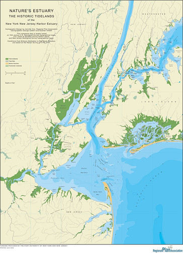
A couple of years ago, the Regional Plan Association produced this map, which shows the extent of tidal wetlands in the late 1700s and 1800s. Notice the green splotches at Flushing Meadows and Eastchester Bay, and think of what the western Sound's ecosystem would be like had those wetlands not be destroyed (and to truly boggle your mind, look at the vast green area of the New Jersey meadowlands).
Jon Christensen, who writes The Uneasy Chair, directed me this morning to something that I had heard about but had yet to check out: the Mannahatta Project, which is being undertaken by researchers at the Wildlife Conservation Society. It's well worth a look:
The aim of the Mannahatta Project is to reconstruct the ecology of Manhattan when Henry Hudson first sailed by in 1609 and compare it to what we know of the island today. The Mannahatta Project will help us to understand, down to the level of one city block, where in Manhattan streams once flowed or where American Chestnuts may have grown, where black bears once marked territories, and where the Lenape fished and hunted. Most history books dispense of the pre-European history of New York in only a few pages. However, with new methods in geographic analysis and the help of a remarkable 18th-century map, we will discover a new aspect of New York culture, the environmental foundation of the city.
It's absurd, of course, to think we can ever get back to those ultimate baselines. They're fascinating and fun. But they're useful too, if only to show us how much we have lost, and to remind us of the fallacy of thinking that what we remember from our youth was an ideal worth aspiring to, a paradise worth regaining. Instead, it's merely one of the points of a shifting basline.
Among the most satisfying parts of "This Fine Piece of Water" to research and write were the chapters in which I tried to show what the region must have looked like to Adriaen Block when he and his Dutch crew first sailed through Long Island Sound in 1612 or 1613. Last week I wrote here about the idea of shifting baselines. What Block found, and what the Native Americans lived, was the baseline for Long Island Sound and its watershed.
A couple of years ago, the Regional Plan Association produced this map, which shows the extent of tidal wetlands in the late 1700s and 1800s. Notice the green splotches at Flushing Meadows and Eastchester Bay, and think of what the western Sound's ecosystem would be like had those wetlands not be destroyed (and to truly boggle your mind, look at the vast green area of the New Jersey meadowlands).
Jon Christensen, who writes The Uneasy Chair, directed me this morning to something that I had heard about but had yet to check out: the Mannahatta Project, which is being undertaken by researchers at the Wildlife Conservation Society. It's well worth a look:
The aim of the Mannahatta Project is to reconstruct the ecology of Manhattan when Henry Hudson first sailed by in 1609 and compare it to what we know of the island today. The Mannahatta Project will help us to understand, down to the level of one city block, where in Manhattan streams once flowed or where American Chestnuts may have grown, where black bears once marked territories, and where the Lenape fished and hunted. Most history books dispense of the pre-European history of New York in only a few pages. However, with new methods in geographic analysis and the help of a remarkable 18th-century map, we will discover a new aspect of New York culture, the environmental foundation of the city.
It's absurd, of course, to think we can ever get back to those ultimate baselines. They're fascinating and fun. But they're useful too, if only to show us how much we have lost, and to remind us of the fallacy of thinking that what we remember from our youth was an ideal worth aspiring to, a paradise worth regaining. Instead, it's merely one of the points of a shifting basline.
posted by Tom Andersen at 9:43 AM
![]()
![]()


1 Comments:
The Mannahaata Project is enticing indeed. Your description of it reminded me of the very interesting book about the history of the City of Chicago: "Nature's Metropolis: Chicago and the Great West" by William Cronon. It begins: "Before the city, there was the land...". Because of Chicago's close economic relationship to New York City, it may be characterized as the 'sequel'.
Post a Comment
<< Home